
News

CURA Celebrates 20 Years
April 6th, 2021 is CURA's 20th anniversary. CURA became official on April 6th, 2001. You can take a brief look at our history and past newsletter for more details on past projects and much more!…

Outreach Recap: Strengthening Legacy Cities with Strong Towns Founder Charles Marohn
On March 12th, 2021, CURA welcomed Charles Marohn, the founder of Strong Towns and the author of Strong Towns: A Bottom-Up Revolution to Rebuild American Prosperity. He argues that the…
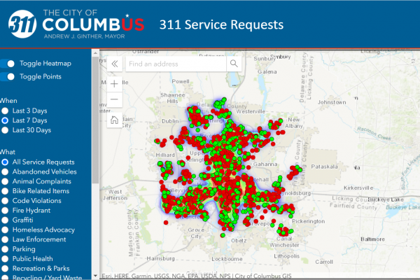
In the News: Ohio State study: 311 statistics can predict opiate, overdose hotspots
Earlier this month, CURA's Director Harvey Miller was interviewed by 10TV news anchor Angela Ann about the recent study of 311 call data related to overdose hotspots in Franklin County, Ohio. To…

Outreach Recap: Strengthening Legacy Cities with Alan Mallach
Earlier this month, CURA hosted acclaimed author (and genuinely nice person) Alan Mallach. Mr. Mallach is a senior fellow at the Center for Community Progress in Washington DC. A city planner,…
Outreach Recap: Strengthening Legacy Cities Panel Discussion
Last month, CURA kicked off our Strengthening Legacy Cities series with a panel discussion from experts living and working around Ohio. Our panelists included:
Ian Beniston AICP, HDFP …
CURA's Director appointed to second term as Chair of the National Academies Mapping Science Committee
Harvey Miller appointed to second term as Chair of the National Academies Mapping Science Committee. The Mapping Science Committee organizes and oversees National Research Council studies that…
Who still needs public transit during the pandemic? Essential workers, minorities, and seniors
By: Luyu Liu, Harvey J. Miller
Background
COVID-19 became a global pandemic due to its contagiousness, fatality rates, and lack of effective…
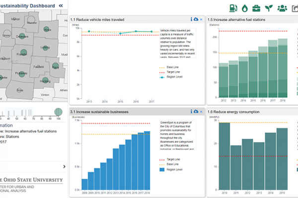
Regional Sustainability Dashboard
CURA and The Mid-Ohio Regional Planning Commission (MORPC) are launching an interactive, online dashboard that provides current and accurate information on Central Ohio’s sustainability…
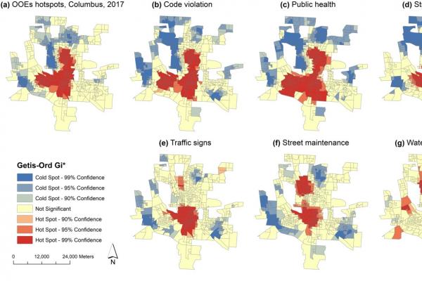
311 calls may predict opioid overdose hotspots
By: Yuchen Li, Ayaz Hyder, Lauren T. Southerland, Gretchen Hammond, Adam Porr & Harvey J. Miller
Background
Opioid use disorder and overdose deaths…