Ghost Neighborhoods

Project Overview
The 1956 The National Interstate and Defense Highways Act impacted lives and cities across the United States by constructing what we now call the Interstate Highway system. Planners of the system intentionally routed some highways through neighborhoods occupied by people of color, particularly Black Americans. Thriving and full neighborhoods were split and, in some cases, even fully demolished for these urban highways. In Columbus, predominantly Black communities such as Bronzeville and Hanford Village were significantly impacted by highway construction and other policy decisions like redlining and urban renewal. By creating 3D virtual reconstructions of these neighborhoods, the Ghost Neighborhoods of Columbus project intends to help people understand the impacts of these policies, offer a window to explore the rich history of these communities, and support historical morphological research. Most prominently, the interactive models will be displayed in Ohio History Connection's Poindexter Village Museum and Cultural Center opening in 2028.
CURA is committed to designing this work in partnership with the community to ensure the models are authentic to the neighborhoods’ history and beneficial to community members today. If you are interested in organizing a co-design event in the Near East Side, conducting oral histories to share stories of these neighborhoods, or providing direct feedback to our team, email cura@osu.edu.
Try out our models using the link below and consider providing your feedback via the accompanying survey!
Focus Areas
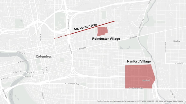
CURA is currently focusing on three historic areas in the Near East Side of Columbus: Poindexter Village, Mt. Vernon Ave, and Hanford Village.
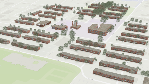
Poindexter Village in 1940
Poindexter Village was one the first public housing projects in the United States; Franklin Delano Roosevelt attended its dedication in 1940. The village was named in honor of community leader, Rev. James Preston Poindexter and became a close knit community for many in Columbus. Although most of the buildings have since been demolished, the two remaining buildings will be part of the new Poindexter Village Museum and Cultural Center.
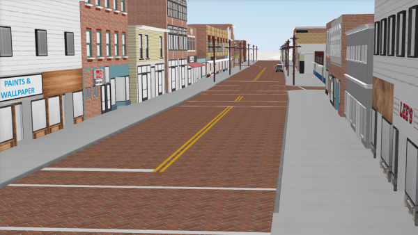
Mt. Vernon Ave in 1951
Mt. Vernon Ave was the commercial heart of the Black community in Columbus in the mid-20th century; the construction of the I-71 highway severed this corridor from Columbus downtown. We are initially focusing on a three-block stretch (from present-day Monroe St. to 20th St.) that had the highest concentration of commercial activity in 1951. The buildings in this area were demolished and some streets removed as part of an urban renewal project in the early 1970s.
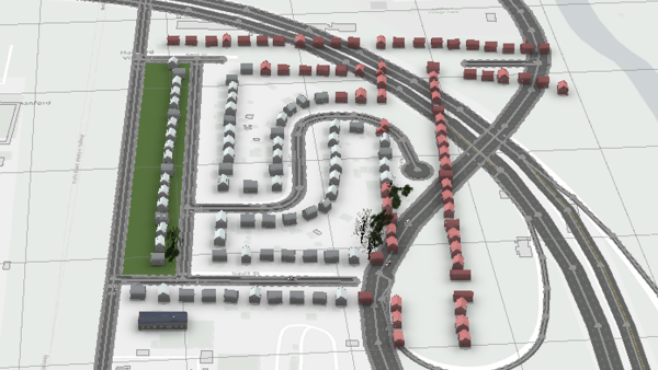
Hanford Village in 1961
Hanford Village was originally established in the early 1900s and became home to many Black residents during the Great Migration. From 1943-1946, Hanford Village’s George Washington Carver Addition was built. This project developed 146 homes specifically for Black veterans of World War II, including Tuskegee Airman. Unfortunately, less than 20 years later, 87 homes—including 67 from the Carver Addition—were relocated or demolished for the construction of I-70. Today, the neighborhood is still divided by the highway.
Methodology
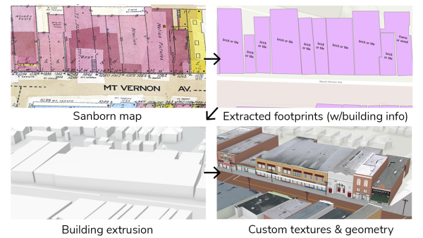
The Ghost Neighborhoods project is developing the models of these neighborhoods primarily using data from Sanborn Fire Insurance Maps. CURA is actively refining a workflow of data extraction from Sanborn Maps, 3D extrusion, and detailed refinement using archival data and community feedback.
Sanborn Data Extraction
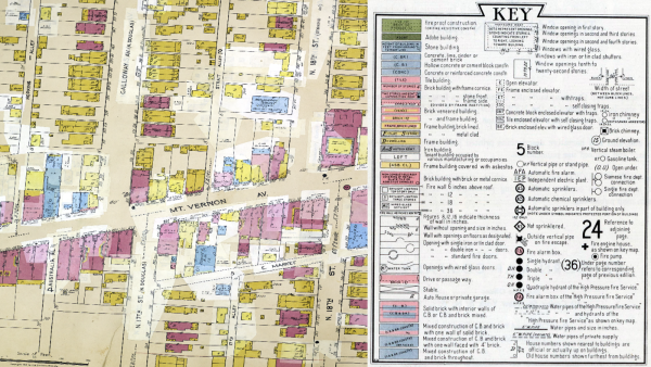
Sanborn Maps were hand-constructed for US cities across the country for fire insurance purposes and date back to the 19th century. The maps contain a wealth of building level data including building footprints, uses, construction material, number of stories and more. An image of a Sanborn map and accompanying key can be found below. CURA has developed machine learning techniques to automatically extract building footprints and other key information from Sanborn maps.
3D Building Extrusion
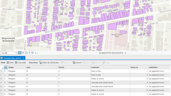
By creating a GIS database through this machine learning process (example below), we’ve opened the door to building 3D visualizations. CURA researchers use the building footprints and number of stories to create basic 3D models in Esri City Engine.
Detailed Building Refinements
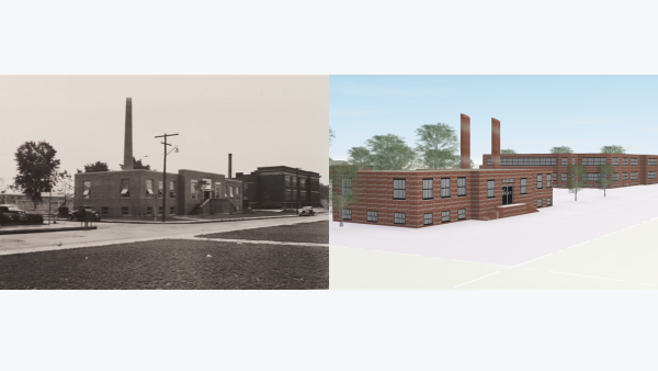
For our focus neighborhoods, CURA researchers have used historic photographs, street imagery, archival data, and memories from community elders to build realistic geometries and textures (building exteriors) for key buildings. Ongoing community engagement will lead to further improvements in the models' accuracy and immersion.
Future Goals
CURA is working toward increasing the scalability of our methods. We're hoping to extract additional data from Sanborn Maps, such as windows per floor and building addresses, to build more detailed initial models quickly. Once we achieve greater efficiency in our processes, there are broad applications for this work:
- With more plausible initial models, there is a stronger foundation for co-design with communities
- With neighborhood or city-wide models, we could create high-resolution urban morphology databases to conducts spatial analyses of the built environment over time
- With building addresses extracted, we could automatically incorporate data from city directory data or other online databases
To learn more about our methodology, read our publication in the journal, PLOS ONE or our publication in the International Journal of Digital Humanities. You can also read press about the project below.
We are grateful to our partners in this work. Ohio History Connection has been instrumental in guiding our engagement efforts and is building the museum where the community will experience this work. Columbus Metropolitan Library has been a fantastic research partner and has helped us identify countless historical photographs and resources. Finally, Dr. Matt Lewis of the Advanced Computing Center for the Arts and Design has been critical to developing and enhancing our technical workflows.
Ghost Neighborhoods Publications and Press
International Journal of Digital Humanities: From historical maps to lived experiences: A community-engaged approach to 3D urban modeling of neighborhoods prior to urban highways and urban renewal
Ohio State News: Elders’ stories are bringing digital models of lost communities to life
Columbus Dispatch: A look at the $25 million project to preserve a piece of Columbus' Black history
Spectrum News 1 OH: Ohio State students explore old towns using virtual reality
National Neighbors Indicators Partnership: Creating building-level, three-dimensional digital models of historic urban neighborhoods from Sanborn Fire Insurance maps using machine learning
Ohio State News: Turning old maps into 3D digital models of lost neighborhoods
Axios: 3D digital models are resurrecting lost neighborhoods
ZME Science: AI turns old maps of demolished neighborhoods into 3D digital models
Interesting Engineering: Machine learning resurrects post-WWII neighborhoods in 3D using old maps
Engineering and Technology: ‘Walking’ through lost neighborhoods possible with 3D digital maps
New Atlas: Technique turns maps of lost neighborhoods into possible VR landscapes
Study Finds: AI rediscovers lost neighborhoods from decades ago, creates virtual reality towns
Planetizen: Visualizing Columbus Before Freeways
Columbus Dispatch: Columbus neighborhoods cut up by freeways being reimagined by Ohio State researchers in 3D
Columbus Business First: Ohio State project hopes to tell stories of Columbus 'ghost neighborhoods' destroyed by highways
Spectrum News 1 OH: Researchers recreating lost neighborhoods
Axios Columbus: Mapping out our "ghost neighborhoods"
Undesign the Redline: Un-Design the Redline Activists and Agitators 2022
Ohio State News: Recreating “ghost neighborhoods” destroyed by highways
The Lantern: Hale Hall to exhibit on Columbus' Redlining History
Ohio State Office of Outreach and Engagement: 2026 Program of Excellence in Engaged Scholarship
Columbus Landmarks: Frederick J. Holdridge Outstanding Group Award
At the Translational Data Analytics Institute's 2023 Interdisciplinary Research Fall Forum, a professional MC performed a 'rap-up' of a panel featuring Ghost Neighborhoods.