
Ghost Neighborhoods of Columbus
The 1956 The National Interstate and Defense Highways Act impacted lives and cities across the United States by constructing what we now call the Interstate Highway system. Planners of the system routed some highways, often purposely, through vulnerable and deprived neighborhoods occupied by people of color. Once thriving and full neighborhoods, these neighborhoods were split and, in some cases, even fully demolished for these urban highways. Within the span of a few years these neighborhoods lost not only homes and people, but shops, jobs and their vitality. This caused an economic downturn in many of these neighborhoods that lasts until the present day. Remaining residents still live with the negative consequences of these highways, including disconnections, poor air quality, noise and road trauma. Some of the most impacted neighborhoods in Columbus include Hanford Village and Bronzeville on the east side, and Flytown just north of downtown.
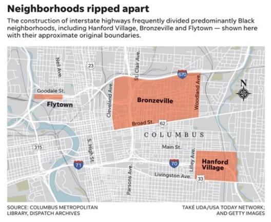
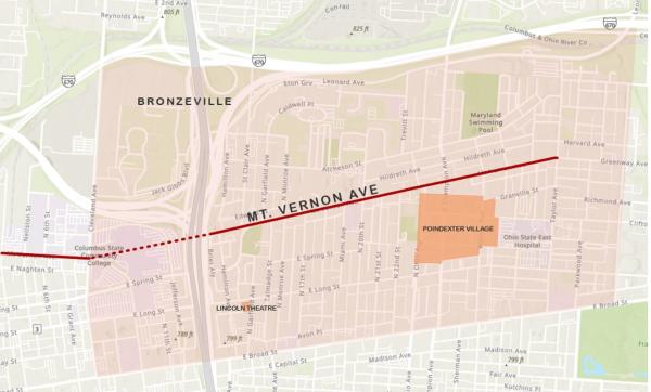
Columbus Dispatch map showing three of the neighborhoods in Columbus most impacted by urban highway construction
CURA has launched the Ghost Neighborhood of Columbus project to help people understand what was destroyed by urban highway construction in the 20th century, and support research on reconstruction of the wealth, vitality and activities that have vanished. The core data we are using to reconstruct these neighborhoods are Sanborn Fire Insurance Maps: these are hand-constructed maps of US cities dating back to the 19th century, created for fire insurance purposes, containing a wealth of building level data.
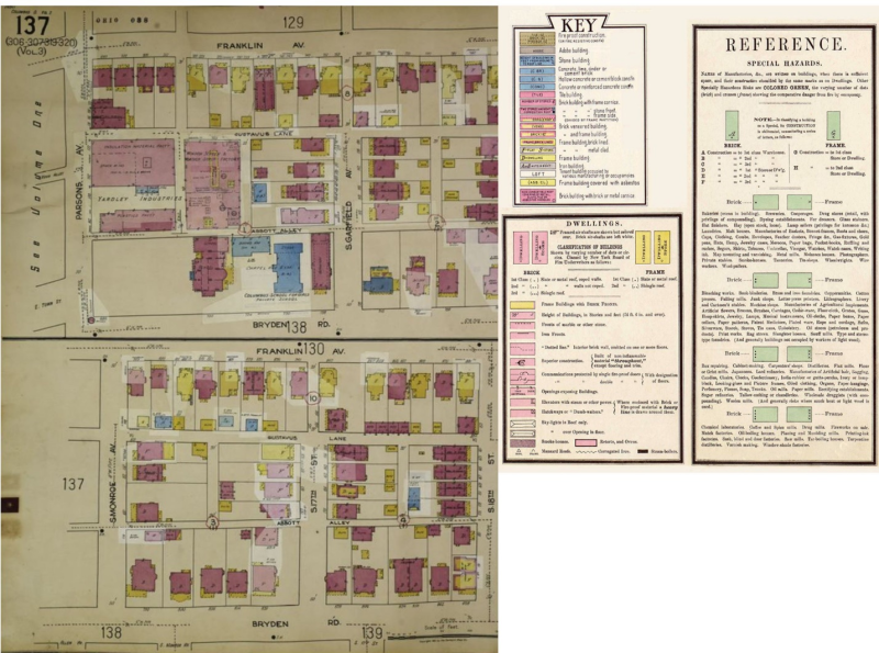
Sanborn Fire Insurance map. The left side shows streets and buildings on the east side of Columbus in 1961. The legend on the right side illustrates the rich information available in these historic maps; some date back to the 1880s.
Hanford Village (1961)
Hanford Village is a good example of a neighborhood heavily impacted by highway construction. This was a vibrant community for newly returning Black World War II veterans. Hanford Village’s George Washington Carver Addition was platted in 1945. 146 homes were constructed during 1945-1947. Currently, the neighborhood is only a small fragment of what it once was. The construction of Interstate 70 and Alum Creek Drive demolished or moved 67 of the homes in this subdivision.
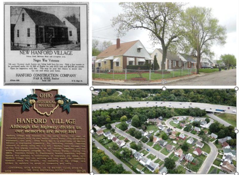
Photos of Hanford Village, Columbus (source: Columbus Dispatch)
The Ghost Neighborhoods project will highlight these lost and damaged neighborhoods by using machine learning/artificial intelligence techniques to extract data from the Sanborn maps to create populate a GIS database, allowing the creation of 3D visualizations and support spatial analysis. The 3D visualization will show existing and demolished structures. The figure below shows one of the first visualizations produced by the research team: buildings in Hanford Village in 1961. The blue double lines show what is now I-70, and the red buildings are those that were destroyed by its construction.
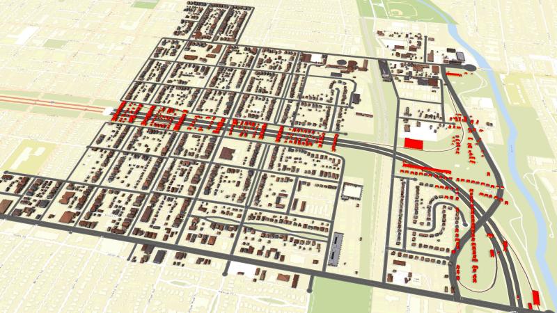
This image shows the Hanford Village and Driving Park neighborhoods in 1961. It also shows the modern-day I-70 highway, and the buildings destroyed or relocated for its construction, highlighted in red. The project is also gathering historic photos, archival documents, and narratives to create story maps that will tell the tales of neighborhoods lost to highway construction.
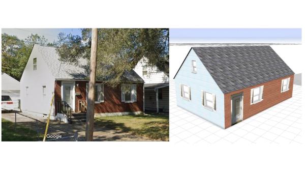
Note that the buildings textures (exteriors) are plausible but not accurate. We applied simple rules within ESRI City Engine to generate these textures. In our current phase, we are studying historical and current day photos to build more accurate building textures. The image below shows a Google Street View image of a still existing 1940s Cape Cod home in the George Washington Carver Addition in Hanford Village with a 3D model (click for larger image).
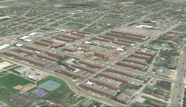
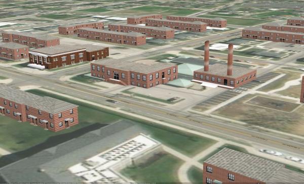
Poindexter Village (1940)
Poindexter Village was one the first public housing project in Ohio and one of the first in the United States: Franklin Delano Roosevelt attended its dedication in 1940. Most of the buildings have since been demolished. The images below shows our 3D model of Poindexter Village, superimposed on a present day aerial image. The top image shows an overview; the bottom image shows building details (click for larger images). The only buildings that remain are the church (the building with the columns) and the two residential buildings to its left in both images.
A museum and visitor center is planned for the two remaining buildings. We are working in partnership with the Ohio History Connection to develop a 3D model for this center and explore delivered via the web, onsite digital displays or a 3D printed tabletop model.
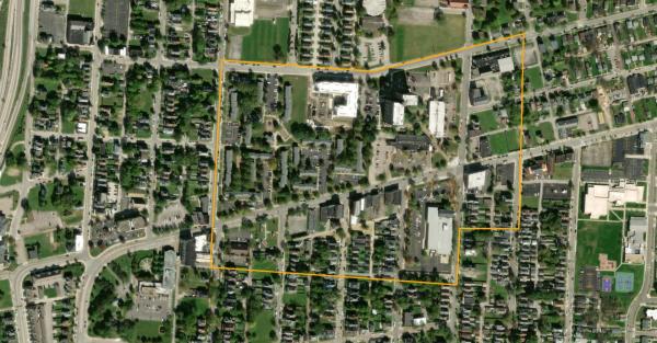
Mt. Vernon Ave in 1951
Mt. Vernon Ave in 1951 is our newest study site and time, supported by a seed grant from the Battelle Engineering, Technology and Human Affairs (BETHA) Endowment fund at The Ohio State University and in partnership with the Columbus Landmarks Foundation and the City of Columbus Near East Area Commission (NEAC). CLF and NEAC are pursuing historic district designation for Mt. Vernon Ave.
Mt. Vernon Ave was the commercial heart of the Black community in Columbus in the mid 20th century; the construction of the I-71 highway severed this corridor from Columbus downtown. We are initially focusing on a three-block stretch that had the highest concentration of commercial activity in 1951. The buildings in this area were demolished and some streets removed as part of an urban renewal in the early 1970s.
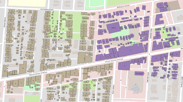
Our initial study area is a three-block stretch of Mt. Vernon Ave between present-day Monroe St (to the west) and 20th Street (to the east). The image below shows our study area with the 1951 buildings footprints superimposed (click for larger images). Based on our research this was the largest concentration of commercial activity in 1951. It was also the site of an ill-considered urban renewal project in 1971 under the Model Cities program.
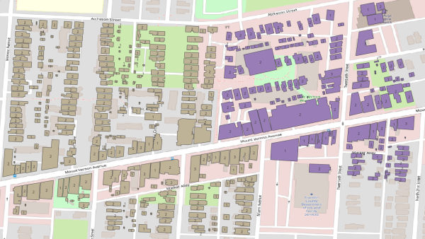
The next three images illustrate the information derived from the Sanborn maps. The first image shows building footprints with uses overlaid on a present-day map. D = dwelling; F = flat (apartment); S = store (commercial); A= automobile (garage).
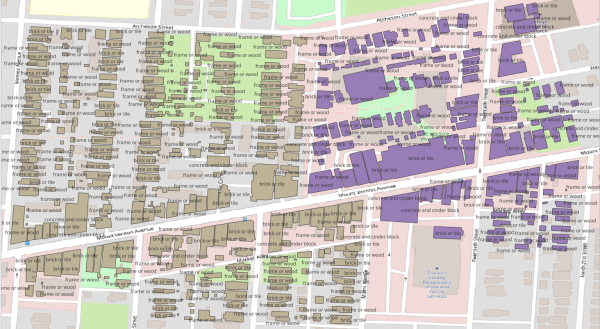
We are currently conducting archival research to determinate accurate building textures, especially for the commercial buildings, and adding this information to the models. We are also working with Dr. Matt Lewis to develop an in-situ augmented reality experience of Mt. Vernon Ave in 1951.
The team will also be doing archival research to gather and georeference historic photographs, narratives and other archival material that can bring these lost neighborhoods to life in a story map format. We will also be linking these building data to historic city directories that contain owner and business information organized by street address.
The Ghost Neighborhoods Rap
A professional MC from EventRap hired as a discussant to “rap-up” our project presentation at the OSU TDAI/SI Interdisciplinary Research Fall Forum, November 9 2023.
Members of the Ghost Neighborhoods Team (past & present):
CURA Administration Team
- Nicole Williams
- Michelle Hooper
- Gerika Logan
- Harvey Miller
- Ningchuan Xiao
- Adam Porr
CURA Students
- Mostahidul Alam – PhD student, Geography
- Troy Harbin – Undergraduate student, GIS
- Jialin Li – PhD student, Geography
- Yue Lin – PhD student, Geography
- Mahnoush Mostafavi Sabet – PhD student, Geography
- Josie Stiver – Undergraduate student, City Planning
- Shubh Thakkar– Undergraduate student, Geography
- Ahmad Tokey, PhD student, Geography
- Di Wang – PhD student, History
- Xinyi Wu – PhD student, Civil, Environmental and Geodetic Engineering
Collaborators
- Rebecca Kemper – Columbus Landmarks Foundation
- Matt Lewis – Department of Design and Advanced Computing Center for the Arts and Design, OSU
- Rongjun Qin – Civil, Environmental and Geodetic Engineering, OSU
- Jason Reece – Knowlton School, OSU
- Joshua Sadvari – OSU Libraries
- Shelbi Toone – Ohio History Connection
Follow our progress at https://cura.osu.edu/projects/existing/ghost-neighborhoods.
Ghost Neighborhoods Press
PLOS ONE: Lin, Y., Li, J., Porr, A., Logan, G., Xiao, N., & Miller, H. J. (2023). Creating building-level, three-dimensional digital models of historic urban neighborhoods from Sanborn Fire Insurance maps using machine learning. PLOS ONE, 18(6), e0286340. https://doi.org/10.1371/journal.pone.0286340
National Neighbors Indicators Partnership: Creating building-level, three-dimensional digital models of historic urban neighborhoods from Sanborn Fire Insurance maps using machine learning
Ohio State News: Turning old maps into 3D digital models of lost neighborhoods
Axios: 3D digital models are resurrecting lost neighborhoods
ZME Science: AI turns old maps of demolished neighborhoods into 3D digital models
Interesting Engineering: Machine learning resurrects post-WWII neighborhoods in 3D using old maps
Engineering and Technology: ‘Walking’ through lost neighborhoods possible with 3D digital maps
New Atlas: Technique turns maps of lost neighborhoods into possible VR landscapes
Study Finds: AI rediscovers lost neighborhoods from decades ago, creates virtual reality towns
Planetizen: Visualizing Columbus Before Freeways
Columbus Dispatch: Columbus neighborhoods cut up by freeways being reimagined by Ohio State researchers in 3D
Columbus Business First: Ohio State project hopes to tell stories of Columbus 'ghost neighborhoods' destroyed by highways
Spectrum News 1 OH: Researchers recreating lost neighborhoods
Axios Columbus: Mapping out our "ghost neighborhoods"
Undesign the Redline: Un-Design the Redline Activists and Agitators 2022
Ohio State News: Recreating “ghost neighborhoods” destroyed by highways
The Lantern: Hale Hall to exhibit on Columbus' Redlining History
Columbus Landmarks: Frederick J. Holdridge Outstanding Group Award
Collaboration
This week, CURA met with board members of the James Preston Poindexter Foundation, Poindexter Village Museum project manager, Shelbi Toone, and the Center of Folklore Studies gentrification course. The James Preston Poindexter Foundation consists of residents and passionate allies that lead community discussions surrounding the Near East Side. In Autumn 2022, Katey Borland and Miranda Martinez co-led a class about the gentrification of Columbus. This class toured the City to learn more about gentrification and displacement with residents and local experts. They were then introduced to the Ghost Neighborhoods of Columbus project by CURA. Katey and Miranda both saw a way their class could get help further the efforts of Ghost Neighborhoods by gathering stories and artifacts from the elders of the community.
This spring, CURA, Poindexter Village, and The Center for Folklore Studies will collaborate to create materials to share the stories of the people affected by urban renewal and highway expansion.