Research: Creating building-level, three-dimensional digital models of historic urban neighborhoods from Sanborn Fire Insurance maps using machine learning
In a paper, just published in PLOS ONE, CURA researchers develop machine learning techniques that can turn historical fire insurance maps of US cities into digital 3D urban models, at scale. This article was authored by former CURA GRA's, Yue Lin, and Jialin Li; former CURA Consulting Manager, Adam Porr, CURA Outreach Coordinator, Gerika Logan; CURA Associate Director, Ningchuan Xiao; and CURA Director, Harvey Miller.
Abstract
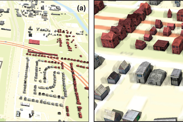
Sanborn Fire Insurance maps contain a wealth of building-level information about U.S. cities dating back to the late 19th century. They are a valuable resource for studying changes in urban environments, such as the legacy of urban highway construction and urban renewal in the 20th century. However, it is a challenge to automatically extract the building-level information effectively and efficiently from Sanborn maps because of the large number of map entities and the lack of appropriate computational methods to detect these entities. This paper contributes to a scalable workflow that utilizes machine learning to identify building footprints and associated properties on Sanborn maps. This information can be effectively applied to create 3D visualization of historic urban neighborhoods and inform urban changes. We demonstrate our methods using Sanborn maps for two neighborhoods in Columbus, Ohio, USA that were bisected by highway construction in the 1960s. Quantitative and visual analysis of the results suggest high accuracy of the extracted building-level information, with an F-1 score of 0.9 for building footprints and construction materials, and over 0.7 for building utilizations and numbers of stories. We also illustrate how to visualize pre-highway neighborhoods.
Read the full article below!
<